Smart Streets in South Bend
- Student
- Paige Melinis
- College(s)
- School of Architecture
- Faculty Advisor
- Kimberly Rollings
- Class Year
- 2015
What are Smart Streets?
Smart Streets, also known as Complete Streets, are streets that are designed for everyone to use. This means they are designed with all types of users in mind, to create safe and easy access for everyone, including pedestrians, bicyclists, motorists and transit riders of all ages and abilities.
- Livability: Vehicles stop less on one-way streets, which makes it more difficult for bikers and pedestrians to cross streets.
- Navigation: One-way street networks are confusing for drivers, leading to more vehicle-miles traveled and negative impacts on the environment.
- Safety: Vehicle speeds tend to be higher on one-way streets, and drivers are likely to pay less attention to the road because there is no conflicting traffic flow.
- Economics: Two-way streets increase visibility of businesses, leading to greater sales.
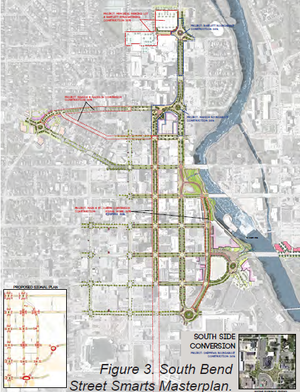
Smart Street renovations on East Jefferson Boulevard, completed in the fall of 2014, are illustrated in Figure 4. E. Jefferson Blvd. serves as one of the major streets leading to downtown, and renovations have made the street a more desirable place to be. Conversion from four to three lanes with a turning lane, safer intersections, and bike lanes were introduced in order to increase walkability and attract more customers to the businesses.
What is road dieting?
Road dieting is an increasingly popular method for improving street design. When an existing street is re-proportioned to better suit all modes of transportation, businesses see more economic success, and the street becomes a more desirable place to be. Most neighborhood main streets were originally designed with 4-lanes of travel, two lanes of traffic in each direction, as well as car parking on either side of the road. By decreasing the number of travel lanes to 3, there is room for a turning lane in the middle, as well as bike lanes on either side of the road.
- Bioswales can be placed in various locations, from medians, to cul-de-sacs, to other traffic calming strategies.
- Bioswales increase the overall amount of nature on a street, like trees and plantings, contributing to lower stress levels and more attractive places to walk and shop.
- Bioswales conserve water. By filtering storm water runoff, the plants can use the filtered water from rain as opposed to fresh water for plantings without bioswales.